|
WE OFFER:
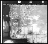
Aerial photography at all scales and converting its to digital form.Aerial Triangulation- by the means of analytical and digital methods, on the basis of points survey using such programs as HATS, ImageStation Stereo Display and other and with adjustment by independent bundles method through programs such as Path-B, Photo-T, Match-AT.
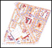
Elaboration of digital vectorised large scale maps, 2D & 3D, both as basic maps and as specialized elaboration for power industry, water and sewage management , for design of telecommunication networks- cellular telephony and radio nets. For digitizing of aerial photos and for maps elaboration we used programs and applications of such world known trade marks as Bentley (MicroStation , I/RAS B&C) Autodesk (AutoCad, AutoCad Map)), Geographics, Descartes,) and other.
Digital Terrain Model (DTM or Digital Elevation Model-DEM), both for natural and artificial features (buildings, engineering structures) in the format TIN as well as GRID. Measurement of DTM is made on digital stereoplotters and photogrammetric workstations and completed with manual measurement of break lines , spot heights, structural lines, planar areas and so on. Match-T and SCOP programs are used for building and control of DTM.
Elaboration of digital orthophotomaps as a base for physical planning, environment protection, agriculture, forestry, monitoring of natural disasters threat etc.
We obtain digital orthophotomaps through using of digitized aerial photos and final interpolated DTM, parameters of external orientation derived from aerial triangulation and by applying of digital methods of rectification. Phodis-OP application from Zeiss and Base Rectifier from Intergraph are used for orthorectifying. Other program Ortho-Vista (Zeiss) is used for creation of orthophotomaps.
|